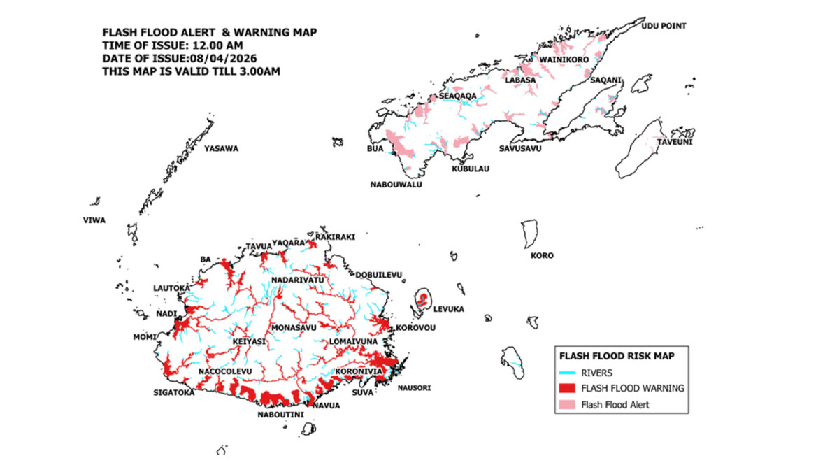
The Nadi River and Tuva River in Nadroga continue to rise and are now above warning levels and as a result, a river flood warning is in force for all low-lying communities near and downstream of these rivers, including floodplain areas.
A flood alert is also now in place for Ba and Tavua, especially as high tide is expected around 10.12pm, combined with the delayed impact of heavy rainfall over the past 24 hours.
A flood warning remains in force for all low-lying flood-prone areas adjacent to and downstream of the Tuva River in Nadroga, Nawaka River and Nadi River.
The public is strongly advised to remain alert, avoid flooded areas, and take necessary precautions.
Category 3 Tropical Cyclone Vaianu was located about 255km west-southwest of Nadi and 300km west of Kadavu earlier this afternoon.
TC Vaianu is currently moving south-southeast at about 18km per hour and is expected to lie 305km south-southwest of Kadavu or 420km south of Nadi at 6pm tomorrow.
Forecast to midnight tomorrow for the Fiji group indicates that over land areas of the Northern Division, the Yasawa and Mamanuca groups, the western half of Viti Levu (from Sigatoka–Coral Coast through Nadi to Rakiraki), Kadavu, and nearby smaller islands, strong to near gale-force northerly winds are expected, with speeds of up to 60 km per hour and gusts of up to 95 km per hour.
Elsewhere, expect strong northerly winds with wind speeds up to 45 kilometres per hour and gusts up to 70 kilometres per hour.
Expect flash flooding of flood prone low-lying informal settlements and communities, businesses and Irish Crossings leading to traffic disruptions.
Also expect surface flooding on streets in urban areas with poor drainage.
There will also be wet roads and reduced visibility, especially during heavy rain, increasing the risk of road accidents.
If you live in a flood prone area, please move to an evacuation centre or to higher ground.
Also ensure that you have taken all the necessary precautions for you and your family.
Stay with us for developments.