Tropical Cyclone Urmil is expected to potentially intensify to Category 3 within the next 12 hours, however it is not expected to directly impact Fiji.
Be prepared for heavy rain, flooding and strong winds if you are living in flood prone areas.
The Nadi Weather Office says TC Urmil was located 400 kilometres southwest of Port Villa or about 790 kilometres west-southwest of Nadi at midday.
They say TC Urmil is expected to be located 640 kilometres southwest of Nadi at midnight and 720 kilometres south of Nadi at midday tomorrow.
The Weather Office says even though the system will not directly impact the country, the system is expected to bring strong northerly winds averaging at 45 kilomtres per hour with gusts up to 75 kilometres per hour.
Occasional to periods of rain with thunderstorm is expected from this evening.
A Heavy Rain Warning is in force for all of Fiji, while a Flash Flood Alert is in effect for the Western Division from Sigatoka to Nadi, Lautoka, Ba, Tavua and Rakiraki.
A Strong Wind Warning remains in force for land areas of the Western Division, Yasawa and Mamanuca Groups, Kadavu and nearby smaller islands, Lau, Lomaiviti, Macuata, Bua and nearby smaller islands.
Possible impacts include flash flooding of flood-prone settlements and communities, businesses, and river crossings, which may cause traffic disruptions.
Surface flooding may occur on streets in urban areas with poor drainage, and wet roads with reduced visibility during heavy downpours that increase the risk of road accidents.

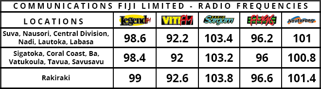
Stay tuned for the latest news on our radio stations