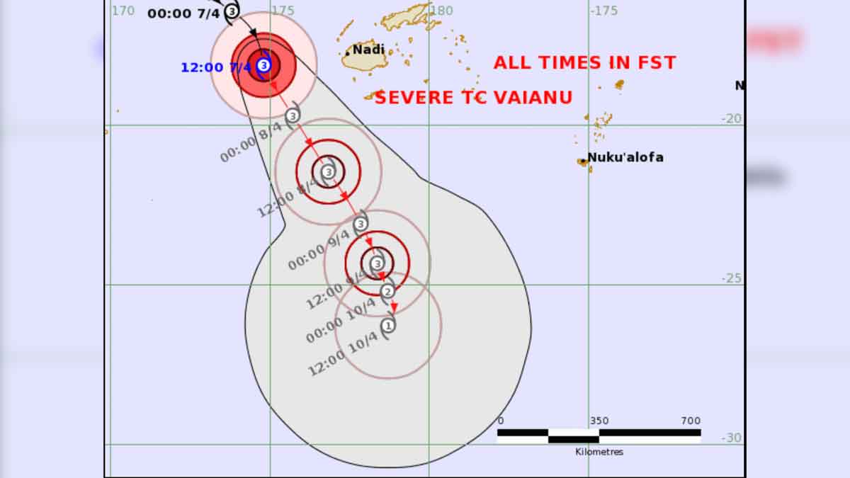
Be prepared for flash flooding of low lying and flood prone areas, and isolated damages to houses made of old corrugated iron and timber or unshielded structures in exposed communities, and broken tree branches and fallen power lines as the centre of Category 3 Tropical Cyclone Vaianu tracks between Fiji and Vanuatu.
A heavy rain warning remains in force for the entire Fiji group.
A flash flood warning remains in force for Viti Levu.
A flash flood alert remains in force for the rest of Fiji.
A strong wind warning remains in force for the land areas of Fiji.
Cyclone Vaianu was located about 250 kilometres west-southwest of Viwa and 280 kilometres
west of Nadi earlier this afternoon.
Vaianu is currently moving south-southeast at about 18 kilometres per hour and is expected to lie about 310 kilometres south-southwest of Kadavu and about 410 kilometres south of Nadi at midday tomorrow.
Forecast to midnight tomorrow for the Fiji group: Over land areas of the Northern Division, Yasawa and Mamanuca groups, the western half of Viti Levu [from Sigatoka-Coral Coast through Nadi to Rakiraki], Kadavu and nearby smaller islands: Expect strong to near gale force northerly winds with speeds up to
60 kilometres per hour and gusts up to 95 kilometres per hour.
Elsewhere, expect strong northerly winds with wind speeds up to 45 kilometres per hour and gusts up to 70 kilometres per hour.
Expect flash flooding of flood prone low-lying informal settlements and communities, businesses and Irish crossings leading to traffic disruptions.
Also expect surface flooding on streets in urban areas with poor drainage.
There will also be wet roads and reduced visibility, especially during heavy rain, increasing the risk of road accidents.
If you live in a flood prone area, please move to an evacuation centre or to higher ground while it is still daylight.
Also ensure that you have taken all the necessary precautions for you and your family.
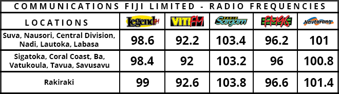
Stay with us for developments.