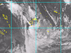
The tropical depression is still located in the Fiji waters and the Nadi Weather Office said people should expect continuous heavy rain and possible flash flooding.
Acting Director at the Nadi Weather Office Alipate Waqaicelua said strong winds are expected to affect Kadavu, Beqa, Vatulele and nearby islands.
Waqaicelua said people should refrain from going out to sea today and he said the people in Kadavu, Beqa, Vatulele and nearby islands should be prepared for gale force winds while for the rest of Fiji, expect heavy rain later today.
The good news is that the depression has not upgraded to a cyclone as it continues to take an east-south-east direction.
The tropical depression was located near 19 decimal 4 South, 175 decimal 3 East or about 290km south-west of Nadi at 4am this morning.
The depression is currently moving east-south-east at 20km per hour and is expected to intensify further and possibly turn into a Tropical Cyclone in the next 24 hours.
Close to its center, the depression is estimated to have winds with average speeds up to 50km per hour with momentary gusts to 80km per hour.
Damaging gale force winds with average speeds of 55 to 65km per hour with momentary gusts to 100km per hour are expected within 110 to 280km away from the center.
On this track and if the depression continues to intensify, the center is expected to lie about 310km south-south-west of Nadi or 220km southwest of Kadavu at 4pm today.
Story by: Vijay Narayan
Feature
Gale force winds expected in Kadavu, Beqa and Vatulele