People are advised to take the necessary precautions as a Tropical Cyclone Alert is now in force for the Western Division.
The Nadi Weather Office says the Tropical Depression was located about 710km West North West of Nadi earlier today.
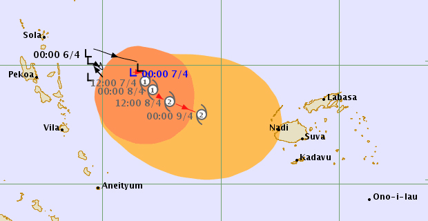
The Weather Office says the system is expected to track South Eastwards and expected to further intensify into a Category 1 Tropical Cyclone within the next 6 to 18 hours while remaining to the far West of Fiji, over open waters.
Nadi Weather Office Director Ravind Kumar says as the system moves South Eastwards, it is expected to track close to land areas and it has the potential to further intensify to a Category 2 or Category 3 Tropical Cyclone because of favourable environmental conditions for further intensification.
The Depression is currently slow moving.
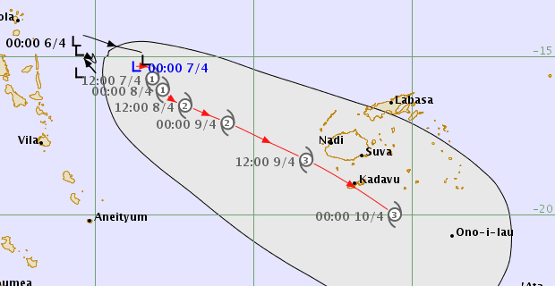
Threat Forecast Map as at 1:43pm Saturday 7th April [met.gov.fj]
Forecasters say that if the depression continues to intensify and stays on the current track then it may bring damaging winds over the Western Division by tomorrow night.
A strong wind warning remains in force for all land areas of Western Viti Levu which includes Sigatoka to Rakiraki, Yasawa and Mamanuca Group, Vanua Levu, Taveuni and nearby smaller islands and the Northern Lau Group.
People can expect strong winds from tonight.
People in the Western Division from Sigatoka to Rakiraki can expect winds with average speeds of 50 kilometres per hour with momentary gusts to 75 kilometres per hour.
The Weather Office says that people in the Western Division can expect periods of heavy rain, thunderstorms, flooding of low lying areas including sea‑flooding of low lying coastal areas.
For Vanua Levu, Taveuni and nearby smaller islands and the Northern Lau Group, strong winds with average speeds of 50 kilometres per hour with momentary gusts to 75 kilometres per hour.
People in these areas can expect periods of heavy rain, thunderstorms and flooding.
These expected strong winds will be able to bring down some temporary or loose shelters and also damage crops.
For the rest of Fiji, periods of heavy rain and thunderstorms over most places.
Please note that with more rain forecast and soil being saturated, there is high risk of severe river flooding especially in the Western Division. The approaching system has the potential to produce more than 120mm of rainfall in 24 hours this weekend.
As the system moves closer to the Group, expect periods of heavy rain and thunderstorms with rough to very rough seas in the weekend and could even increase to high seas.
Damaging heavy swells are also expected with high risk of severe river flooding.
People living in flood prone and low lying areas are reminded to take all necessary precautions and remain alert and to keep listening to us for latest weather updates.

Stay tuned for the latest news on our radio stations