A heavy rain alert has been issued for the Eastern half of Viti Levu which includes areas from Pacific Harbour, Navua, Suva, Nausori, Tailevu and Rakiraki, and Vanua Levu, Taveuni, Yasawa and Mamanuca.
A flash flood warning has also been issued for low lying areas and areas adjacent to Vatukacevaceva to Rakiraki Town, Dreketilailai to Qawa River, Labasa, Upper Nadarivatu and Monasavu.
A flash flood alert is in force for low lying areas and areas adjacent to Sigatoka River, Tuva River and the upper Wainimala catchment.
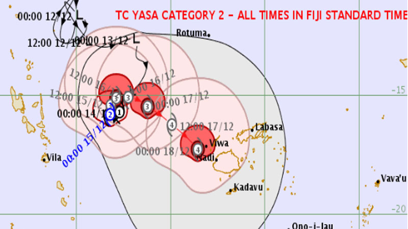
People are advised to take necessary precautions as Tropical Cyclone Yasa is expected to make a clockwise loop, intensify into a Category 4 cyclone and head towards Fiji.
Category 2 TC Yasa was located about 640 kilometres West North West of Nadi at midnight.
At this stage, the Nadi Weather Office says Cyclone Yasa is expected to be located just to the West of Viti Levu with severe cyclone strength on Friday however people should be prepared for damaging winds as Yasa can come closer to us after the loop.
By Saturday, the system is expected to slip just to the West of Viti Levu and Kadavu and continue to move southward.
Expect the weather to gradually change for most places as the rain bands associated with Cyclone Yasa moves over the group later today and into tomorrow bringing continuous heavy rain especially over Yasawa and Mamanuca Group then gradually spreading to the rest of the group by Thursday.
Expect the heavy rain to persist into Saturday and gradually start easing from Sunday.
Due to anticipated widespread heavy rain, there is risk of river flooding and flash flooding of low lying and flood prone areas.
Winds are expected to pick up and become damaging from later Thursday especially over the Yasawa and Mamanuca Group, Northern Viti Levu and Kadavu before gradually spreading eastwards to the rest of the group.
While TC Yasa is expected to have severe cyclone strength (possibly category 3 or stronger) when it passes close to the west of the group while remaining over open waters, it may cause widespread power failures, blow away roofs and considerable damage to structures especially weak-structured houses.
Damaging winds can also uproot big trees and cause total damage to shallow rooted plants and crops.
High waves about 3 metres is expected over Yasawa and Mamanuca waters from today.
From tomorrow we can expect high waves more than 5 metres over South West Viti Levu waters, Yasawa and Mamanuca waters and Kadavu Passage. These high waves pose a risk of coastal flooding in these areas.
Sea conditions will also be hazardous for sailing and any other sea activities.
Meanwhile, another Tropical Depression, TD03F which lies just to the north of Tonga has also intensified further into a category 1 tropical cyclone and named tropical cyclone Zazu at midday yesterday.
Stay with us for developments.