The Nadi Weather Office is calling on people to take all the necessary precautions Tropical Cyclone Evan continues to intensify and is highly likely to enter the Fiji waters late Sunday.
Director, Alipate Waqaicelua said the projected path is being monitored and people need to be prepared and hope for the best.
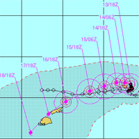
Waqaicelua said Evan is currently a category 3 cyclone and is located 1,020 kilometers to the East North East of Labasa.
It has completed its u-turn and is slowly moving over Samoa.
Based on projections it is expected to head towards the northern parts of Tonga by tomorrow afternoon before heading to the Northern Division in Fiji late Sunday.
In the next 12 to 24 hours, Cyclone Evan is expected to become a category 4 cyclone.
Waqaicelua said it should be noted that the cyclone is getting good conditions to continue to strengthen and it may even go up to category 5 when it enters the Fiji waters.
A category 4 cyclone has very destructive winds between 159 to 200 kilometres per hour and the effects from this can include significant roofing loss, structural damages and widespread power failure.
A category 5 cyclone has winds over 200 kilometres per hour and the effects are extremely dangerous with widespread destruction according to the tropical cyclone scale.
Fijivillage advises people take all the necessary precautions - secure your homes, store water and food, buy batteries, torches and ensure you have a transistor radio to listen to the weather bulletins. Do not wait until Sunday afternoon and start running around.
Waqaicelua said the system is being closely monitored and continuous updates will be given.
Stay with Fijivillage for continuous updates.
Story by: Vijay Narayan