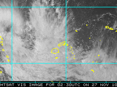
The Nadi Weather Office said the Western Division should be experiencing the real or direct effects of the tropical depression by early tomorrow afternoon.
The Nadi Weather Office cyclone forecaster said as the Tropical Cyclone Alert remains in force for Fiji, the Western Division may not be getting strong wind, however throughout tonight into tomorrow morning this will change.
He said the tropical depression was located 440 km west north west of Nadi as of midday today.
He added the system is expected to bring strong winds by tomorrow afternoon.
He said the rest of the group should be experiencing similar conditions.
Once again the or those who have access to a map the tropical depression was located near 16 decimal 6 South, 172 decimal 5 east or about 440 km west northwest of Nadi.
The depression is currently moving east-southeast at 9km per hour.
It is expected to intensify further and possibly become a tropical cyclone in the next 30-36 hours.
On this track if the depression continues to intensify, it may bring damaging gale force over the Western Parts of Fiji and Kadavu by later Sunday.
Periods of rain, heavy at times with squally thunderstorms, flooding, including sea flooding of low lying coastal areas is expected from later tomorrow.
For Mariners a strong wind warning remains in force for Fiji.
Once again please bear in mind that the Nadi Weather Office said it is expected by tomorrow afternoon wind speeds will be picking up in the Western Division as the tropical depression moves closer to the group.
The general public is forewarned to closely monitor the current weather situation and stay with Fijivillage for further developments.
Story by: Ana Naisoro
Feature
Cyclone alert remains in force for entire Fiji Group